 The Coopers Rock Area
The Coopers Rock Area
![]()
The Coopers Rock State Forest is the largest and most popular state forest in West Virginia. Around 350,000 people a year visit the area for picnics, fishing, hiking, camping, and to just enjoy the spectacular view from Overlook Rock.
Coopers Rock is about ten miles east of Morgantown on I-68. It consists of about 13,000 acres of land covering both sides of the interstate. The most popular attraction is the Overlook area, but the hiking trails, camping, and picnic areas get lots of use. Also nearby is Chestnut Ridge Park, the Chestnut Ridge trout pond, and the West Virginia University Forest.
The area has belonged to the state since 1936, when it was first used as a game preserve. It was used previously for farming, timbering, and the iron making. During the Depression, the Civilan Conservation Corps (CCC) developed the land for public use. They built roads, walkways, picnic areas, a firetower, the caretakers' houses, and shaped the Overlook area to the way it looks today.
Click on the link at the top to get a Cooper's Rock bumber sticker.
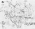 |
This is a map of the Coopers Rock Area The park is located on I-68 just east of Morgantown, at the Cooper's Rock Exit. The overlook and main picnic area is about three miles from the exit, south of the interstate. |
 |
Raven's Rock overlook |
 |
Down the trail |
 |
One of the Rocks |
 |
Henry Clay Iron Furnace |
 |
More Rocks |
The historical information and drawing of the Henry Clay Iron Furnace is from A Guide to Coopers Rock State Forest, by Judith S. Rodd.